Final stop, Washington

After nearly three weeks on the road from Juneau to Seattle, we are back in the states and with full access to the cyber world. We did our best to document the incredible Canadian landscape we crossed over, the people we met, and the places we stopped at along the way in order to share our experience with friends, family, and whoever else cares to look into our road lives or is interested in the sort of trip we took. We traveled a diverse landscape and found some of the most incredible places we’d ever seen. We don’t have enough hands to count the number of times I said “I like it here.” In a short time, I’ll be starting work in Seattle and Lara will be off to wherever her wanderlust takes her, probably crewing some ship somewhere awesome or paddling rivers wherever. Click on the links below to read about our trip and see some pictures!

Part One: The Klondike

Part Two: Stewart-Cassiar

Border Crossings

Part Three: The National Parks of the Canadian Rockies

Part Four: Stoked on BC

Part Five: Close to Home Now in the Sea to Sky Corridor

e4d39c39c80dd824c7ff9bbde1cdb791

Sea and Sky

As we headed south from Whistler area, the landscape already started to feel like home. Now, the places I’d be driving through until Seattle would be a part of my extended backyard. When I caught first glimpse of the Chief, I had to hang up the phone with my mother just so I could focus on it. As a climber, it was exciting to finally see it. The Chief is a great granite fortress that overlooks the town of Squamish. It is the crown jewel of big wall climbing in the region. In fact, it is probably the most well know climbing destination in Canada–and for good reason.

Highlights: Looking at the Chief and knowing one day I will be on it. SQUAMISH. Climbing in Cheakamus Canyon. Visiting Whistler. Bypassing Vancouver. Easy Border Crossing! The entire Sea to Sky Corridor.

Reflecting back on the past year, 2013

2013 was good for me. I met great people, got out of my comfort zone, and shared my travels and passions with the people that matter most. We are more than half way through 2014 now, but after going through the 2013 file in my iPhoto account, I couldn’t help but reminisce. It’s been quite the privilege. With 4 months of 2014 left, we will have to just wait and see if 2014 can top 2013.

Only three days into 2013, and I was off with some of my closest friends for a climbing trip to Cochise Stronghold, Queen Creek, and Red Rocks. Thinking back now, 2013 was jampacked with exploring climbing destinations around the states. Many of my road trips were climbing-centric. I climbed at Penitente Canyon in Colorado’s San Luis Valley, bouldered at Moe’s Valley outside of St. George, Utah, did my first multi-pitch climb–and of all places, Yosemite, climbed at Sharma’s home gym, did 7 pitches of a climb in Mazama, Washington, got my ego put in check at Index and Devil’s Lake, fell in love with Tensleep, didn’t climb enough at Spearfish Canyon in South Dakota, and made a spring break trip to the Red River Gorge in Kentucky. More importantly, I got to share these beautiful places with so many awesome people.

I got to share Moab and Southwest Colorado with mom and grandma, went on tons of road trips–one with Caden, one with Cameron, and one alone. Got an insider’s tour of Austin with Kelly, spent an awesome several days in Cape Cod, spent a long weekend with friends at Duncan’s house on Squam Lake in New Hampshire, spent a ton of time on Earl’s Trails in the Holyoke Range, went on my first multi-day canoe trip–100 miles down the Connecticut River with Mike, and went to a ton of national parks–Badlands, Yellowstone, Yosemite, Crater Lake,  Arches, Canyonlands, Mesa Verde, Zion, Sand Dunes, and Devil’s Tower. Woah, can’t believe it.

Thanks everyone who was a part of it all! Here’s to more good times, good friends, and travelin’!

With a Little Help From My Friends

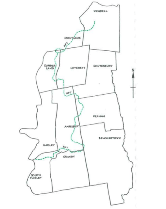
Our original plan was a two-day hike of the Robert Frost Trail, but because of the sort of obligations that arise when leaving a place for a long time, in my case, a drive to Alaska for the summer, we had to settle for one day. Our plan? To see just how far we could push ourselves on the trail using the Robert Frost as our proving grounds. We hadn’t run in weeks—the end of the semester busyness kept us more indoors than we liked. We assumed we would make it around thirty miles which was just over our longest daily mileages. So we set up water caches every ten miles and hit the trail by 7 powering through the ups and downs of the Holyoke Range—a familiar and enjoyable stretch.

In recent years, Max has been my go-to trail running partner—it’s hard to find anyone who wants to run as far as I do in our circle of friends. We talked about everything on the trail—family, future plans, goals and aspiration, communion with nature, personal philosophies, childhood and getting older.

For us both, we’d be graduating from Hampshire College, moving on to new and exciting ventures. While walking along the Robert Frost, I was reminded of the many memories I’d made in these woods. Over the years, on my own and with various classes, I had been to many of the places Max and I passed through—the Lawrence Swamp and Mount Toby with Noah Charney’s Field Naturalist class, Mount Orient and Wendell State Forest with Karen Warren’s classes, the Holyoke Range with my Uncle John. In a sense, the trip provided closure to my time at Hampshire.

Around twenty miles, our bodies were feeling beat from the undulating topography of the Hadley/ Amherst area. We were getting cold and hungry and the conflicting inner dialogue was in full volume: Why the hell are you doing this Joe? There is no way you’ll make it ten more miles… Don’t disappoint Max… You definitely can’t do this… There are worse things in the world… Maybe if I trained harder I’d be able to make it farther, but I haven’t so I might as well give up… But we ate a meal, engaged in more conversation and pushed on. We felt similarly around thirty miles. “Hey Max,” I said. “I just want you to know that if you want to give up, I wouldn’t be bothered.” He said the same and we continued.

Near mile 45, it was like we were in trail limbo. Not only were we tired from hiking more than we ever had in a day, but we were over two hours into the darkness of night following orange blazes by headlamp and we were sleepy-tired now. I thought I was going to die—and the trail seemed like it’d never end. Max tried making conversation, but I could only focus on each step. So, he started whistling. Familiar tunes made steps easier and I began to feel a lot less hopeless. In the cool misty night, the only thing I heard was Sergeant Pepper’s Lonely Hearts Club Band. After the namesake song, Max transitioned into “With a Little Help From My Friends” like on the album. I’m not sure if he whistled it on purpose, but the song carried me to the end. At mile 47 and fifteen hours later in Wendell State Forest, we had made it. We both beat our personal records by over twenty miles—not bad—it was much more than we imagined we’d do. We fought our against our negative inner dialogue and told each other that we could do it—and so we did.

Image

Trip Highlights: seeing a moose, bard owl, and a porcupine. Pigpen boulders, the old UMOC cabin near Mount Toby, old cellar holes, Puffer’s Pond. Diverse ecosystems—swamps, ponds, farmland, riverbanks, mill ponds, dense forests, deep ravines, and wooded ledges.


For more information on the trail: http://www.amherstma.gov/DocumentCenter/Home/View/610